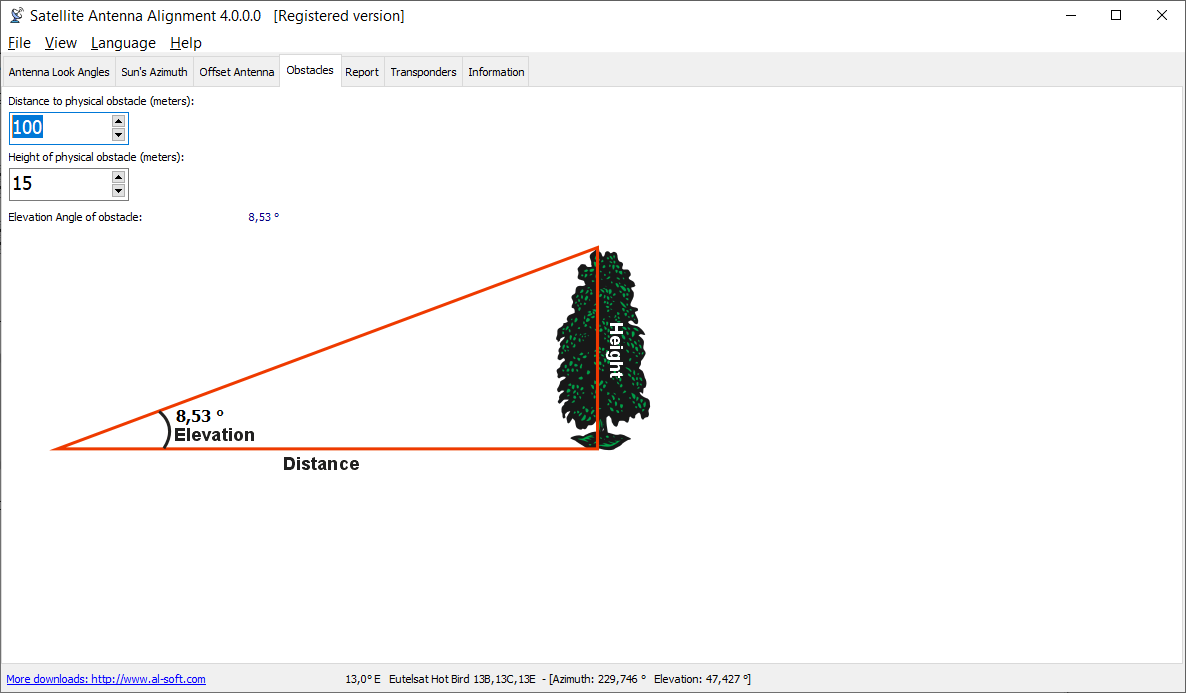
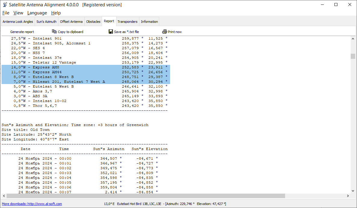
The program «Satellite Antenna Alignment» is used to calculate the angles necessary for installing satellite dishes. The main difference from similar software is the possibility to calculate the position for all satellites at once. Thus, you get a clear picture about what satellites can be physically visible from the location where the dish will be installed. It should be kept in mind that the program makes a purely theoretical calculation according to formulas and in real circumstances a lot of additional factors should be taken into account when a satellite dish is installed. These factors include various obstacles (buildings, trees), the landscape, the altitude, transponder orientation, polarization, etc. Nevertheless, this program will allow you to evaluate the position quite precisely. The calculation can be saved to a text file, copied to the Windows clipboard or printed out at once. It is possible to save the list of locations for which the calculation is done. Later on, you will not have to enter the coordinates of these locations again. Just select them from the table.
![]() This is an evaluation version "Satellite Antenna Alignment" that you may try and distribute free of charge for private non-commercial usage, as long as you need. For regular or commercial usage you are required to order the full version.
You will receive license code (via e-mail) that enable full functionality without nag screen and other restrictions.
For online ordering, please visit the "Satellite Antenna Alignment" online order page. Payment by Credit/Debit Card, PayPal, Wire transfer, Purchase order, Check/Cash accepted.
This is an evaluation version "Satellite Antenna Alignment" that you may try and distribute free of charge for private non-commercial usage, as long as you need. For regular or commercial usage you are required to order the full version.
You will receive license code (via e-mail) that enable full functionality without nag screen and other restrictions.
For online ordering, please visit the "Satellite Antenna Alignment" online order page. Payment by Credit/Debit Card, PayPal, Wire transfer, Purchase order, Check/Cash accepted.
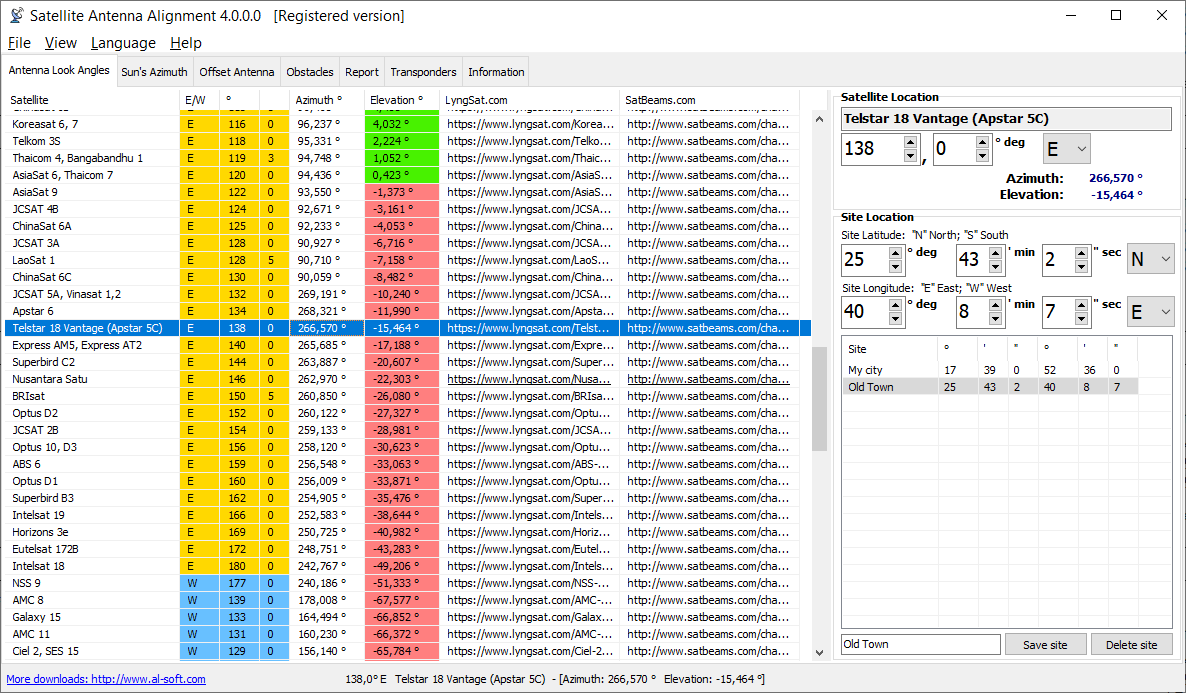
You should start working with the program from entering the geographical coordinates of the location where you are going to install the satellite dish. Enter your coordinates in the "Site location" box. The high latitude is specified with the "N" char, the low latitude is specified with the the "S" char. Similarly, the eastern longitude is with the "E" char, while the western longitude is with the "W" char. After all the coordinates are entered, you will see the calculation for all satellites at once in the table to the left. Their azimuth and elevation are calculated. Azimuth is the direction to the satellite in degrees from the clockwise direction to the north. Elevation is an angle (measured in degrees) between the direction of the signal from the satellite and a tangential plane to the Earth surface in the location. If the elevation is negative, the satellite is below the horizon and it is impossible to receive signals from it in principle. Thus, the satellites whose elevation is a positive value are theoretically visible from your location. If you know the azimuth, you can quickly find the direction to the satellite and see what obstacles (neighboring houses, trees) there are in the way of the signal from the satellite to your dish.


As it was mentioned above, the program uses absolute values and calculates everything according to formulas. Thus, the calculated azimuth is an angle from the true north and not from what your compass may show because a compass is a really unstable thing, especially in a city. It is better to orient it by the sun )
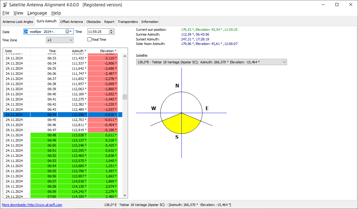
Additionally, the program has a mechanism for calculating the azimuth of the sun and you can do everything without a compass now! The azimuth is calculated for the location the coordinates of which you specified for calculating the azimuths of satellites. You can specify the date (the current date is taken by default) and calculate how the sun moves with a one minute discontinuity. The calculation results are displayed in the table to the left. Both the azimuth and the elevation are calculated for the sun for the current moment of time. Thus, you can install the satellite dish without a compass at all. First, find the azimuth of the satellite you need. Then calculate the azimuth of the sun for the day on which you are going to install the dish. Find the azimuth of the sun that is most close to the azimuth to the satellite and you will see the time (and date) when the sun will be in the same direction where the satellite is. Turn the dish to the sun at the specified moment of time, the azimuth of the sun coincides with the azimuth of the satellite at this moment. Or just note this direction and install the dish later. Remember to specify your time zone for calculation (Moscow: +3 GMT). The program also calculates the azimuths of the sunrise and sunset, as well as the time and elevation when the sun is exactly in the south.
The program draws a simple diagram representing the four directions. The yellow sector is daytime, its eastern part is sunrise and its western part is sunset. The same diagram can be used to schematically represent the direction to the satellite you need. Select the satellite from the drop-down list and the red line will show the direction to it (azimuth). If the elevation is negative, no red line is drawn (the satellite is not visible).
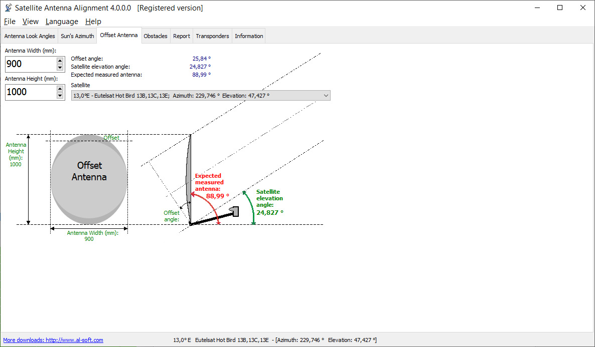
Offset satellite dishes are widely spread now. When such a dish is completely vertical, it already has some elevation (~20-25 degrees). You can enter the size of your offset dish (height and width) and the program will calculate the exact elevation for this dish. The calculation is done only for dishes whose height is greater than width. Enter the size of the dish in millimeters. Here you will see the elevation to the selected satellite and the angle you should actually install you dish at (in degrees from the Earth surface).
Altitude (Elevation): Altitude is the angle up from the horizon. Zero degrees altitude means exactly on your local horizon, and 90 degrees is "straight up". Hence, "directly underfoot" is -90 degrees altitude.
Azimuth: Azimuth is the angle along the horizon, with zero degrees corresponding to North, and increasing in a clockwise fashion. Thus, 90 degrees is East, 180 degrees is South, and 270 degrees is West. Using these two angles, one can describe the apparent position of an object (such as the Sun at a given time).
Donating is possible online with the help of PayPro website. This is a large website dedicated to selling Shareware programs. Process of donating looks like registering a shareware. The price is set to $10. If you want to donate more, you can "order" multiple copies. PayPro accepts all major credit cards, checks, paypal etc.
You don't need to make a donation. You can continue downloading my free software without charge. But after a while you may come to think "I really like this program - let's make a donation to say thanks". Maybe "Satellite Antenna Alignment" helped you out in you job - remember the license they're released under has no restrictions. That's when you should donate if you can!